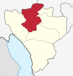
Wanging'ombe District
Appearance
Wanging'ombe District | |
|---|---|
 location in Njombe Region | |
| Coordinates: 08°51′S 034°38′E / 8.850°S 34.633°E | |
| Country | |
| Region | Njombe Region |
| Area | |
| • Total | 3,437 km2 (1,327 sq mi) |
| Population (2022) | |
| • Total | 191,506 |
| • Density | 56/km2 (140/sq mi) |
Wanging'ombe District is one of the six districts of the Njombe Region of Tanzania, East Africa. The administrative seat is in Igwachanya.[1] According to the 2022 Tanzania National Census, the population of Igunga District was 191,506 in 2022.[2]
History
[edit]Wanging'ombe District was formally established when it was gazetted in March 2012. It was created out of part of the old Njombe District that had been in Iringa Region.[1]
Wards
[edit]As of 2015, Wanging'ombe District was administratively divided into 21 wards:[3]
Notes
[edit]- ^ a b Staff (9 March 2012). "Tanzania: State Gazettes New Regions, Districts". Daily News. Dar es Salaam, Tanzania.
- ^ "Wanging'ombe (District, Tanzania) - Population Statistics, Charts, Map and Location". www.citypopulation.de. Retrieved 2024-02-11.
- ^ Wanging'ombe District Council: Council Strategic Plan for the Year 2015/2016 – 2019/2020 (PDF). United Republic of Tanzania, President's Office, Regional Administration and Local Government. 2015. p. 2. Retrieved January 31, 2024.
